地址: 500 (From 500 To 598 Even) GARRISON DR, ADGER, AL 35006-2630, USA
35006-2630是什么? 35006-2630是 500 (From 500 To 598 Even) GARRISON DR, ADGER, AL, USA的5加4位邮编。下面是详细信息。
35006-2630基本信息

-
邮政编码5加4:
35006-2630 -
邮政编码5:
35006 -
加4?26304-digits that are used to identify a geographic segment within the 5-digit delivery area, such as a city block or a group of apartments or an individual high-volume receiver of mail, or any other unit that could use an extra identifier to aid in efficient mail sorting and delivery. This code is the low end of the range of +4 Codes that pertain to this ZIP Code. ZIP+4 Codes associated with nondelivery areas are composed of valid ZIP sector numbers and "ND" for the ZIP segment number, for example 12345-12ND. Non-deliverable areas are areas to which the USPS does not deliver mail, such as vacant lots and land that borders railroad tracks. Mailers should not match an address identified as a nondelivery area. If you absolutely must have numeric characters in the Plus4Code column, you may treat "ND" values as "00" (zero zero).:
-
国家:
U.S. - 美国 -
州:
AL - 阿拉巴马州 -
区县:
CountyFIPS: 01073 - Jefferson County -
城市:
ADGER -
街道?GARRISON DRThe official name of a street as assigned by a local governing authority. The Street Name column contains only the street name and does not include directionals (EAST, WEST, etc.) or suffixes (ST, DR, BLVD, etc.). This element may also contain literals, such as PO BOX, GENERAL DELIVERY, USS, PSC, or UNIT. Numeric street names that have numeric components that are four characters (or less) in length at are justified such that the low-order digit of the number is positioned in the fourth position of the street name column. This shift is made so that the numeric street names appear in numeric sequence.:
-
街道后缀?DR (车道)The street suffix: For Example: ST = Street RD = Road DR = Drive LN = Lane:
-
记录类型?S: 街道An alphabetic value that identifies the type of data in the record. Record type codes include the following: G = General delivery H = Highrise F = Firm S = Street P = PO box R = Rural route/highway contract:
地址

- 主要地址低位数字?
A house, rural route, highway contract box, or post office box number; the numeric or alphanumeric component of an address preceding the street name; the low-end address in a range of addresses. Often referred to as house number.: 500
- 主要地址高位数字?
A house, rural route, contract box, or Post Office box number. The numeric or alphanumeric component of an address preceding the street name. The high-end address in a range of addresses. Often referred to as house number.: 598
- 主要地址奇/偶码?
Code that identifies the side or sides of a street for which a given address range is applicable. For street, highrise, firm and multi-carrier records, B = Both sides of a street, E = Even side of a street (even-numbered addresses in the range); O = Odd side of a street (odd-numbered addresses in the range). For general delivery, post office box, and rural route/highway contract records, this code will always be "B" (both).: Even
- 主要范围: 500, 502, 504, 506, 508, 510, 512, 514, 516, 518, 520, 522, 524, 526, 528, 530, 532, 534, 536, 538, 540, 542, 544, 546, 548, 550, 552, 554, 556, 558, 560, 562, 564, 566, 568, 570, 572, 574, 576, 578, 580, 582, 584, 586, 588, 590, 592, 594, 596, 598.
请单击"更多地址示例"查看整个列表。
500 GARRISON DR, ADGER, AL 35006-2630
502 GARRISON DR, ADGER, AL 35006-2630
504 GARRISON DR, ADGER, AL 35006-2630
506 GARRISON DR, ADGER, AL 35006-2630
508 GARRISON DR, ADGER, AL 35006-2630
510 GARRISON DR, ADGER, AL 35006-2630
512 GARRISON DR, ADGER, AL 35006-2630
514 GARRISON DR, ADGER, AL 35006-2630
516 GARRISON DR, ADGER, AL 35006-2630
518 GARRISON DR, ADGER, AL 35006-2630
520 GARRISON DR, ADGER, AL 35006-2630
522 GARRISON DR, ADGER, AL 35006-2630
524 GARRISON DR, ADGER, AL 35006-2630
526 GARRISON DR, ADGER, AL 35006-2630
528 GARRISON DR, ADGER, AL 35006-2630
530 GARRISON DR, ADGER, AL 35006-2630
532 GARRISON DR, ADGER, AL 35006-2630
534 GARRISON DR, ADGER, AL 35006-2630
536 GARRISON DR, ADGER, AL 35006-2630
538 GARRISON DR, ADGER, AL 35006-2630
540 GARRISON DR, ADGER, AL 35006-2630
542 GARRISON DR, ADGER, AL 35006-2630
544 GARRISON DR, ADGER, AL 35006-2630
546 GARRISON DR, ADGER, AL 35006-2630
548 GARRISON DR, ADGER, AL 35006-2630
550 GARRISON DR, ADGER, AL 35006-2630
552 GARRISON DR, ADGER, AL 35006-2630
554 GARRISON DR, ADGER, AL 35006-2630
556 GARRISON DR, ADGER, AL 35006-2630
558 GARRISON DR, ADGER, AL 35006-2630
560 GARRISON DR, ADGER, AL 35006-2630
562 GARRISON DR, ADGER, AL 35006-2630
564 GARRISON DR, ADGER, AL 35006-2630
566 GARRISON DR, ADGER, AL 35006-2630
568 GARRISON DR, ADGER, AL 35006-2630
570 GARRISON DR, ADGER, AL 35006-2630
572 GARRISON DR, ADGER, AL 35006-2630
574 GARRISON DR, ADGER, AL 35006-2630
576 GARRISON DR, ADGER, AL 35006-2630
578 GARRISON DR, ADGER, AL 35006-2630
580 GARRISON DR, ADGER, AL 35006-2630
582 GARRISON DR, ADGER, AL 35006-2630
584 GARRISON DR, ADGER, AL 35006-2630
586 GARRISON DR, ADGER, AL 35006-2630
588 GARRISON DR, ADGER, AL 35006-2630
590 GARRISON DR, ADGER, AL 35006-2630
592 GARRISON DR, ADGER, AL 35006-2630
594 GARRISON DR, ADGER, AL 35006-2630
596 GARRISON DR, ADGER, AL 35006-2630
598 GARRISON DR, ADGER, AL 35006-2630
地址示例
ADGER AL 35006-2630
UNITED STATES OF AMERICA
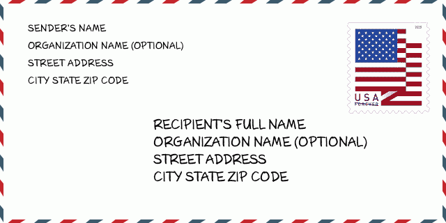
35006-2630信封例子

-
这是美国信封例子。在左上角填写发件人信息,右下角填写收件人信息。必须要填写的信息有发件人和收件人的姓名、街道地址、城市、州还有邮政编码。收件人的地址示例仅供参考。通常来说,如果你不确定九位邮件,你可以仅仅填写五位邮编,以避免邮件丢失。
35006-2630基本含义
-
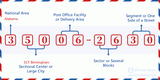
邮政编码 35006-2630 的每个数字代表什么?ZIP+4 Code由两部分组成,前五位数字可以定位到邮局,后四位数字可以确定五位数字递送区域内的一个地理区段。6-7位数字指定区域或几个街区,8-9位数字指定区段或街道的一侧。

- ·运输路线ID?
A 4-digit code assigned to a mail delivery or collection route within a 5-digit ZIP Code. The first character of this identification is alphabetical, and the last three are numeric: Bnnn = PO box Hnnn = Highway contract Rnnn = Rural route Cnnn = City delivery Gnnn = General delivery: R401 (农村线路)
- ·邮递附加低部?
The ZIP Add-On Low Sector and the ZIP Add-On Low Segment together form the ZIP Add-On Low Number. The ZIP Add-On Low Number is the last four positions of a ZIP+4 code; the low-end ZIP add-on in a range of codes; the add-on of the first ZIP+4 code in a consecutive series of ZIP+4 codes assigned to the delivery address. For example, most delivery addresses are assigned a single ZIP+4 code. However, large companies may be given a range of ZIP+4 codes that can be used to route mail to specific departments. A range of ZIP+4 codes can also be assigned to a corresponding range of post office boxes, and each box is mapped, one-to-one, with a ZIP+4 code in the range. A single post office box can also be assigned a range of ZIP+4 codes.: 26
- ·邮递附加低段?
The ZIP Add-On Low Sector and the ZIP Add-On Low Segment together form the ZIP Add-On Low Number. The ZIP Add-On Low Number is the last four positions of a ZIP+4 code; the low-end ZIP add-on in a range of codes; the add-on of the first ZIP+4 code in a consecutive series of ZIP+4 codes assigned to the delivery address. For example, most delivery addresses are assigned a single ZIP+4 code. However, large companies may be given a range of ZIP+4 codes that can be used to route mail to specific departments. A range of ZIP+4 codes can also be assigned to a corresponding range of post office boxes, and each box is mapped, one-to-one, with a ZIP+4 code in the range. A single post office box can also be assigned a range of ZIP+4 codes.: 30
- ·邮递附加高部?
The ZIP Add-On High Sector and the ZIP Add-On High Segment together form the ZIP Add-On High Number, which is the high-end ZIP add-on in a range of codes; the add-on of the last ZIP+4 code in a consecutive series of ZIP+4 codes assigned to the delivery address. Most delivery addresses are assigned a single ZIP+4 code; however, large companies may be given a range of ZIP+4 codes that can be used to route mail to specific departments. A range of ZIP+4 codes can also be assigned to a corresponding range of post office boxes, and each box is mapped, one-to-one, with a ZIP+4 code in the range. A single post office box can also be assigned a range of ZIP+4 codes. (See also ZIP Add-On Code.): 26
- ·邮递附加高段?
The ZIP Add-On High Sector and the ZIP Add-On High Segment together form the ZIP Add-On High Number, which is the high-end ZIP add-on in a range of codes; the add-on of the last ZIP+4 code in a consecutive series of ZIP+4 codes assigned to the delivery address. Most delivery addresses are assigned a single ZIP+4 code; however, large companies may be given a range of ZIP+4 codes that can be used to route mail to specific departments. A range of ZIP+4 codes can also be assigned to a corresponding range of post office boxes, and each box is mapped, one-to-one, with a ZIP+4 code in the range. A single post office box can also be assigned a range of ZIP+4 codes. (See also ZIP Add-On Code.): 30
- ·邮编附加: 2630
- ·范围?
The range of +4 codes. Summing the +4 Code and the +4 Range will give you the high end of the range of +4 Codes that pertain to this ZIP Code.: 0
- ·基本替代代码?
Code that specifies whether a record is a base (preferred) or alternate record. Base records (represented as "B") can represent a range of addresses or an individual address, such as a firm record, while alternate records (represented as "A") are individual delivery points. Government deliveries will only be listed on alternate records with the appropriate government building indicator (federal, state, or city) set.: 基本
- ·财务数字?
A code assigned to Postal Service facilities (primarily post offices) to collect cost and statistical data and compile revenue and expense data. The state number comprises the first two positions of the finance number.: 010070
- ·国会分区数字?
A standard value identifying a geographic area within the United States served by a member of the US House of Representatives or Senate. If Army/Air Force (APO) or fleet post office (FPO), this column will be blank. If there is only one member of Congress within a state, the code will be "AL" (at large).: 06
- ·最后行城市州代码?
An index to the City State file that provides the preferred last-line name for this address range.: Y10008
在线地图

这是地址500 GARRISON DR, ADGER匹配的在线电子地图。您可以使用图中按钮来移动、缩放。该地图信息仅供参考。
地址: 500 (From 500 To 598 Even) GARRISON DR, ADGER, AL 35006-2630, USA
评论


添加新评论